Ward 10 Facts and Stats
Ward History
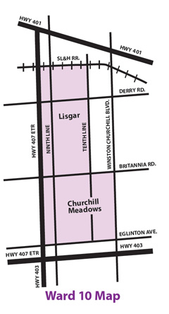
Ward 10 was first created in 2006 when the population of northwest Mississauga was growing to a point where what was then Ward 9 was the largest ward in the city. City Council approved a change that added two new wards: Ward 6 became Ward 6 and Ward 11 with minor tweaks to the boundaries of the adjacent wards, and Ward 9 became Ward 9 and Ward 10. Ward 10 is by-and-large a residential community with many parks, schools and shopping plazas. Its residents come from all over the world, making Ward 10 a beautiful mosaic of culture and heritage. Geographically, Ward 10 is one of the smallest wards in the city of Mississauga. The population, however, continues to grow as new homes and condos fill the landscape.
Ward Boundaries
St. Lawrence & Hudson Railway from Centreline of Hwy 407 to Tenth Line, Tenth Line south to Britannia Road, Britannia Road east to Winston Churchill Boulevard, Winston Churchill Boulevard south to Eglinton Avenue, Eglinton Avenue west to Centreline of Hwy 407, Centreline of Hwy 407 north to the St. Lawrence & Hudson Railway. Click here for a map of Ward 10


Ward 10 Information Guide
I have prepared an information guide for the residents of our ward – old and new alike. The electronic version of the guide is posted here. If you would like a printed copy to put by your telephone for easy reference, please e-mail or call my office and provide your full name and residential address and we will mail one out to you.
Ward 10 Profile
2021 Census Profile for City (incl. Ward 10) (interactive dashboard)
2016 Census Profile for Ward 10 (interactive dashboard)
2011 Census Profile for Ward 10 (18-page PDF)
2006 Census Profile for Ward 10 (17-page PDF)